|
Magellan Explorist 510 Handheld GPS 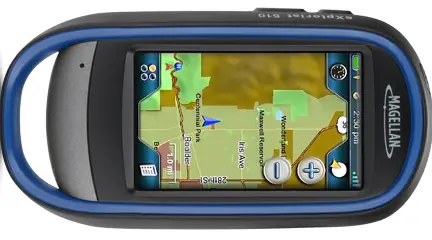 I'll open
with the general list of Magellan eXplorist 510 touted features, then touch on
how well it works and why the hiker or hunter would want this unit. The primary
features include: Preloaded
World Edition maps with a detailed road network, land areas, transportation
points and water features for more than 200 countries. The 2,000 waypoints
guide you toward useful and interesting destinations while geocaching. A 3"
backlit transreflective color touch-screen display, with a WQVGA (240 x 400)
resolution allows for easy viewing while you're outdoors. Also features a
navigational dashboard, OneTouch favorites menu, main menu and contextual
options menu. Supports
paperless geocaching with up to 10,000 geocaches, 200 track logs, 10,000 track
points, 200 routes and 500 legs per route. Built-in
3.2MP digital camera for capturing still images. 2 AA
batteries (included) provide up to 15-16 hours of use. SiRFstar
III GPS technology, along with Satellite Based Augmentation Systems (SBAS) for
locking onto and maintaining your position quickly and accurately in most
environments and receiving directions in moments. High-sensitivity,
WAAS-enabled GPS receiver enhances performance in heavy cloud cover, wooded
areas and canyons, so you don't have to worry about losing the satellite link. Ultracompact
design GPS fits easily into a pocket for convenient portability. Water-resistant
design repels moisture to withstand the elements. MicroSD
card slot: insert a removable media card (not included) containing additional
map data or regional maps to expand your navigational ability. The
Magellan Magellan eXplorist 510 is about a 7 ounce unit in a 5" by x
2-5/8" x 1-1/2" thick platform. As soon as you start to experiment
with it you'll quickly notice that it has a very beefy, sturdy feel to it. It boots
up very briskly, compared to various starter units, and the display is a big
improvement from earlier black and white displays, or the usual low-resolution
color displays. It is a
big, clear LCD with far more detail than you might expect from a handheld GPS.
The claimed battery life from two AA lithium batteries is 16 hours. I'm more
than a bit skeptical about that. The caveat to the big, bright screen is
battery drain. Cold weather does batteries no favors, either. You can maximize
the battery life by dimming the screen down to the lowest comfortably visible
level. If you take a lot of pictures or video, you can expect it to lessen your
battery life. There is a somewhat confusing "hibernate" mode, called
either "suspend mode" or "active suspend mode." It is
confusing to me, perhaps because you can hardly actively hibernate or
frenetically suspend much of anything. The suspend mode on this unit does not
track your movement, as claimed in some places. It does keep GPS lock and gives
you an instant-on type of feature, rather than rebooting the unit, but no more
than that. The 510 takes
video and still images and you can annotate your journey with voice memos. All
three of these features can be attached to a waypoint for future reference. It
is very quick and easy to do this, but don't get the impression that you are
going to get beautiful 8x10 prints out of your images. It is a pinhole camera,
horrible in low-light and adequate for documenting landmarks, various points of
interest or value, but this is not comparable to even an average point and
shoot camera in capture quality. I wouldn't expect it to be, but if you are,
note that this unit does not displace even an average compact digital still
camera in imaging ability. The
quick-start manual is minimal and the PDF you can download isn't much better.
Magellan could certainly include a reasonable paper manual in the box and I
think there is little excuse not to. You can add a MicroSD card to this unit,
but one isn't included. This again rates as a niggle, for a 2GB MicroSD card
costs about five dollars at the moment, a few dollars more for an 8GB card. It
should be included with the unit. You'll need more memory with extensive
picture-taking, a very small amount of video and Magellan does offer several
optional maps that will require more memory than is available in the unit as
supplied. The
hunting usefulness is almost self-explanatory. You use the 510 when scouting
and it will come in handy when going out to a stand or blind in the dark, or
returning to camp in complete darkness. The 3" touchscreen is far easier
to use than the dinky 2-1/4" versions. This unit also has an electronic
compass, altimeter and an alarm. The screen can be viewed in both 2D and 3D
perspectives. The 510
is primarily touchscreen controlled. You have an on/off button at the top of
the unit, with dedicated waypoint marking and camera buttons on the side, but
that's it. It is accurate and it tells you how accurate it is. Right now, as I
type this, it is within 14 feet and the satellite reception is
"Excellent," even indoors. It gives you a graphic showing the number
of satellites it is reading from and the relative strength of the signal from
each one. In my case, that is eleven different satellites. It also has screen capture, sunrise/sunset info, a hunting/fishing calendar and can calculate the area for you if you walk the perimeter. The few things I've mentioned that should be improved are not catastrophic. You're on your own for a microSD card that will set you back a few dollars. The poor included manual is something Magellan really does need to attend to. The consolation as that the eXplorist 510 is very easy to use and needs little additional information to fully enjoy it. |